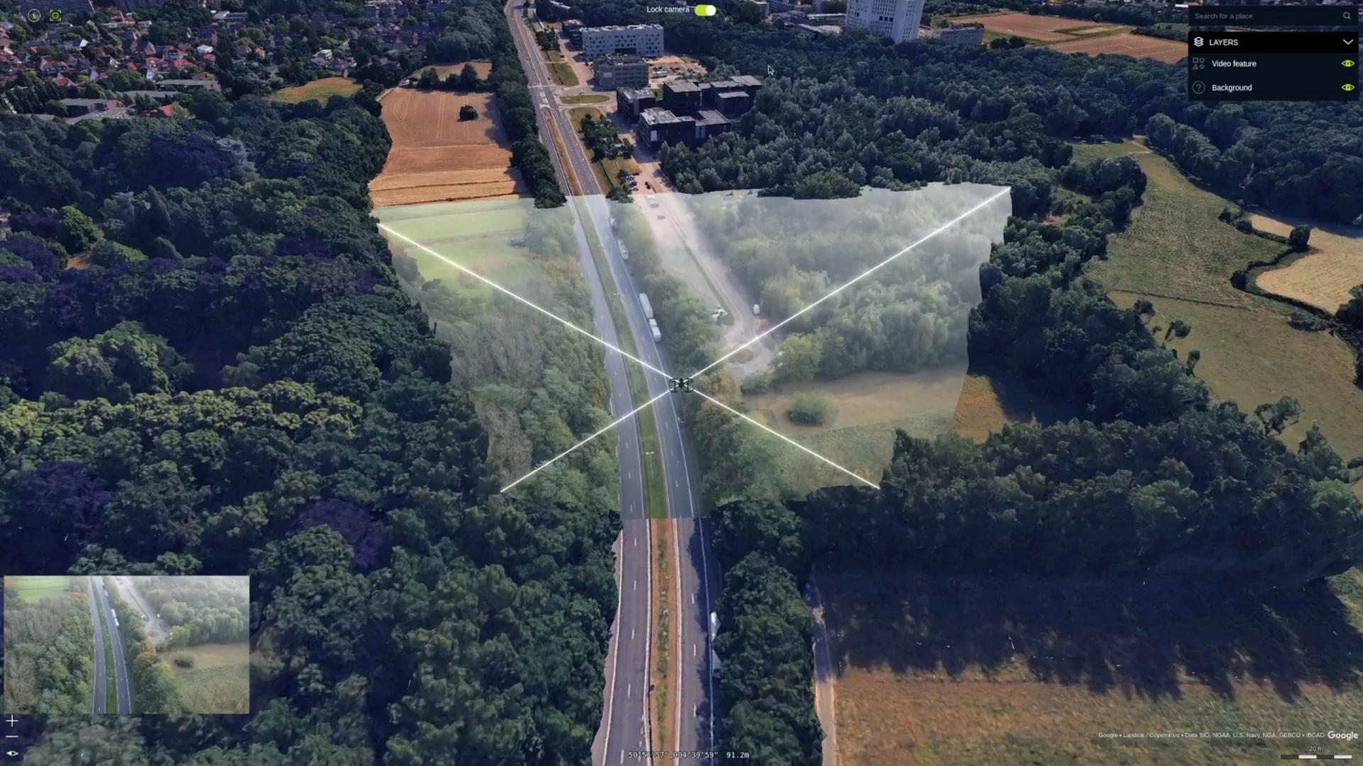
Octave Alto Browser (formerly LuciadRIA) 2024.1 has taken a significant leap forward with the introduction of the video draping API to its browser-based platform in the ever-evolving landscape of geospatial technology. Previously a feature exclusive to Octave Alto Lightspeed (formerly LuciadLightspeed), our desktop product, this powerful tool is now accessible through Alto Browser, bringing dynamic video overlay capabilities to web-based applications.
Let’s explore how this advancement addresses crucial challenges in various industries like defense, government and transportation.
Defense: Real-time situational awareness
Challenge: Defense operations demand up-to-the-minute situational awareness, and traditional maps can’t keep pace with the rapid changes in a dynamic environment
Solution: By integrating live video streams with geospatial data in a browser, defense teams can access real-time visual insights from anywhere without needing heavy desktop installations; this flexibility ensures that decision-makers can act swiftly and efficiently, regardless of location
Civil security: Rapid emergency response
Challenge: In emergency situations, responders need immediate access to live data to make informed decisions and coordinate efforts effectively
Solution: The video draping API enables emergency response teams to overlay live video feeds onto maps in real time, accessible via any browser, allowing responders to visualize the situation on the ground, assess risks and deploy resources more efficiently, even when operating remotely or in the field
Transportation: Efficient traffic and infrastructure monitoring
Challenge: Monitoring traffic flow and infrastructure demands real-time data to prevent congestion and ensure safety
Solution: With the ability to access live video feeds overlaid on maps via a browser, transportation authorities can monitor conditions in real-time from any location, facilitating faster response times and more efficient traffic management
Why a browser-based solution shines
The addition of the video draping API to Alto Browser, alongside its continued presence in Alto Lightspeed, highlights the benefits of a browser-based approach:
Accessibility: Browser-based applications are accessible from any device with internet connectivity, meaning users can view and analyze data on the go, enhancing mobility and collaboration
Ease of use: Alto Browser’s intuitive interface ensures that users, even those without technical expertise, can easily navigate and utilize the video draping feature, democratizing access to powerful visualization tools, enabling broad usage across organizations
Scalability: Browser-based solutions can be rapidly scaled to accommodate more users or additional data sources, making them ideal for organizations looking to expand their capabilities without disrupting new and existing end users
A new era of geospatial visualization
With the introduction of the video draping API to Alto Browser, we’re not just enhancing our product; we’re transforming how users interact with geospatial data. This powerful addition, alongside other cutting-edge features, ushers in a new era of visualization capabilities that empower users across various sectors to harness real-time insights with unprecedented flexibility and ease.
Panoramic imagery: Beyond the video draping API, Alto Browser’s Panoramic Imagery option allows users to integrate and interact with images up to 360 degrees, providing a comprehensive view of environments, enhancing situational awareness and offering a more immersive experience for users in fields such as urban planning, security and tourism
3D Tiles support: Enabling efficient streaming and visualization of large-scale 3D datasets, this capability allows users to explore complex geospatial data seamlessly, providing detailed insights into urban landscapes, infrastructure and natural environments
Advanced styling and labeling: With advanced styling and labeling options, users can customize the appearance of their maps to highlight critical information, ensuring maps are informative and easy to capture at a glance because the symbology is familiar and the focus is on essential information, aiding in better data interpretation and communication.
Real-time data integration: Alto Browser excels in integrating real-time data feeds, allowing users to visualize live information such as traffic, weather or sensor data; this capability is crucial for sectors that rely on timely data for decision-making, such as transportation, emergency response and environmental monitoring.
Alto Browser offers a comprehensive suite of tools that redefine geospatial visualization. Whether it’s enhancing situational awareness in defense, optimizing emergency response efforts in civil security or improving traffic management in transportation, Alto Browser provides the technology needed to make informed decisions in an ever-changing world.